Kilmakevoge Glenmore
now browsing by tag
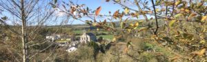
Three Ancient Glenmore Churches

As our third instalment of Chapter 4, of volume 4 of Fr. Carrigan’s History & Antiquities of the Diocese of Ossory (1906) (p. 91-93) three ancient Glenmore Churches will be discussed including; Kilcoan (Weatherstown); Kilbride and Kilmakevoge (also called Kilivory). For all three of these ancient churches Carrigan provided not only the dimensions of the churches, important stones he found in the ruins and nearby Holy Wells. While reading the rest of this fascinating volume in the Mullinavat chapter we came across Big Wood Church which we have also included below because it was supported by nearby Glenmore people.
Kilcoan
“Irish speakers call it Kil-choo-ann, that is, the Church of St. Cuan (pronounced Coo-ann, accent on second syllable). Kilcoan church was a rectangle, 18 feet wide internally, and about 37 feet long, the walls being 2 ½ feet thick. The foundations alone now remain. From the amount of very large rough stones lying on and around the site, it must be concluded that the church was rudely built and was of great antiquity. A graveyard of about two acres is believed to have surrounded it in ancient times; but, at present, all appearances of a burial ground have been obliterated, and the site of the church itself is merely a small patch of unprotected commonage beside the public road. About 150 yards to the south, in the wall of a lane-way, is a great, rugged stone, with a basin-shaped artificial hollow, 12 inches in diameter and 3 inches in depth, cut on the surface” (Carrigan, p. 91).
“St. Cuan’s holy well, called Thubber-chooann, is about a quarter of a mile from the site of the church, in the townland of Flemingstown. Beside it is another holy well, enclosed by a wall and called Thubber-Wizzha (Tobar Muire), or the Blessed Virgin’s Well. Both wells are still frequented for devotional purposes by the people” (Carrigan, p. 91).
Previous to the Reformation the parish and church of Kilcoan belonged to the Priory of Inistioge, as appears from the Red Book of Ossory (Carrigan, p. 91)”
[According to Danny Dowling (1927-2021) the site of this ancient church was in the hamlet of Weathertown in a common at the side of the junction of two lanes. Danny recorded that he spoke with Larry Doyle (c. 1933-2021) of Weathertown regarding some stones Larry uncovered on or near the common in Weatherstown. Larry said that he was working for old “Billy Fitz” (Bill Fitzgerald, c. 1905-1983) of Weatherstown in the late 1960’s or early 1970’s. Larry was clearing an area and came across what appeared to be paving stones. From their description and the location Danny concluded that they may have been part of a floor or yard connected to the ancient church of Kilcoan.]
Kilbride
“In Irish, Kyle-vzheedha (Iold Irish Script that looks like, Cill Drugue) or St. Bridget’s Church. The Church was a rectangle, 43 feet long, internally, and 18 ½ feet wide; but the walls, which were 2 feet, 5 inches thick, are now all fallen to a height of one yard from the ground. The entrance door was in the north wall, near the west gable. The graveyard is very large, with portion of a deep fosse at the south-west end. At the east end of the church is an uninscribed head-stone chamfered on both sides, in front, and having carved on it, in relief, an ancient cross patee, [head] inscribed in a circle; it is now deeply sunk in the ground (Carrrigan, p. 91).

“The baptismal font lies in the fosse at the south-west end of the churchyard; it is square on the outside, and quite rough; the basin is 1 foot 7 inches by 1 foot 5 inches; and is 7 inches deep. A holy water stoup, near the west gable of the church, has a round bowl, like a basin, 11 inches in diameter, and 4 ½ inches deep. Another holy water stoup, much resembling this, was taken away out of the churchyard about 1878. A stone, or rather rock, weighing some tons, in the field under the churchyard, has a basin-shaped cavity on the surface, 1 foot in diameter and 6 inches in depth. Besides this rock is a well, supplied with water by a drain from a holy well about 30 or 40 perches distant, called, Thubbervzheedha or St. Bridget’s Well. The drain was made, and the holy well destroyed in the year 1842″ (Carrigan, p. 91).
Kilbride church and parish belonged to the Augustinian Canons of the Congregation of St. Victor, St. Catherine’s Priory, Waterford” (Carrigan, p. 91).
[For further photos of Kilbride ruins and graveyard taken in 2020 click here]
Kilmokevoge
“The church of Kilmokevoge was originally dedicated to St. Mochaevog, or Pulcherius, abbot and patron of Liath-Mochavog, in the Co. Tipperary; but, after the Norman Invasion, it was placed under the patronage of St. James the Apostle (July 25). In Irish it is called Kill—mo-chac-voogue, that is, the Church of St. Mochaemhog or Mochaevog. In English it is often called Kilivory, from a popular notion that mochaemhog means ivory; but this, writes O’Donovan, ‘is truly ridiculous and in every way incorrect’ (O’Donovan’s Ordinance Survey Letters)” (Carrigan, p. 92).
“Kilmokevoge church is rectangular, and, though long a ruin, is still substantially perfect. Internally it measures 42 feet by 18 12 feet. In the west gable, 12 or 14 feet from the ground, are two narrow loops, somewhat damaged and widely apart, each having at top a round arch cut out of a single stone. There is a door in the north side-wall, 3 feet wide below, but all the upper part of the framework is broken away. The wall here 3 feet 2 inches thick. There is a broken window in the same wall, near the east gable, and another window, also ruined, opposite this, in the south side wall. The east window is blocked up by a mural monument of the Stranges of Aylwardstown. There are corbels in the west end for the support of a gallery; and a broken locker in the north side wall, near the east end. Some very large stones may be observed here and there in the walls” (Carrigan, p. 92).
“The church is undoubtedly ancient, but, as its distinguishing features are either entirely destroyed or seriously injured, its age cannot be fixed. Most probably it is older than the middle of the 12th century. In the south east corner beside where the altar stood, rests the Very Rev. Dr. Lower, P.P., on whose monument may be read:
‘Erected by the Revd. Thos. Malley. Doctor of the
Sacred and White Facility of Bordeaux in memory
of the Rev. Stephen Lower, Bachelor of Lovain,
Doctor of Rome, Prothonotary Apostolic, Archdeacon &
Vicar General of Ossory & Parish Priest of Ida,
Who depd. This life the 9th of Janry, 1800, aged 73 years,
Requiescat in pace. Amen.’
Dr. Lower’s grave is hollowed out to a considerable depth by people taking away the clay therefrom, in the firm belief that it possesses virtue to heal their bodily ailments(Carrigan p. 93). Carrigan later in the volume describes Fr. Lower as “one of the grandest characters that figure in the ecclesiastical history of our Diocese. (Carrigan, p. 210).”
“The Strange monument, besides Dr. Lower’s, commemorates Peter Strange of Aylwardstown, who died Dec. 22nd, 1872, aged 67 years; his father Lawrence; his grandfather, Peter, who died at Aylwardstown, Sept. 1824, aged 89 years; and Thomas F. Strange, who was born, May 11th, 1812 and died Feb. 2nd 1897.”
“In the graveyard, at the end of the church, is an altar tomb marking the burial place of the Forrestalls of Rochestown; it has the family arms, and is inscribed to the memory of Mr. Edmund Forrestall, of Rochestown, who died in 1797, aged 45 years” (Carrigan, p. 93).
“A little to the north of the church is St. James holy well, called, in Irish, Thubber San Seeum, or Well of St. James. The church and parish of Kilmokevoge were appropriated by the Nunnery of Kilkilliheen, probably by David fitz Milo, about the year 1240” (Carrigan, p. 93).
[For further information on Fr. Lower, the saviour of Slieverue in 1798, see our post of 11 November 2020.]
[For photos and headstone inscriptions in Kilivory (Kilmakevoge) churchyard click here.]
Bigwood
“The present chapel of Bigwood was built in 1824, by the contributions of the people of the neighbouring townlands in the parishes of Mullinavat, Kilmacow, Slieverue and Glenmore; and to the present day the inhabitants of these same townlands, no matter to which of the four parishes they may belong, look on Bigwood chapel as their own, pay their share of its expenses, and contribute to all parochial collections held here. The old chapel of Bigwood, erected some time after 1787 and discontinued in 1824, stood at the extreme end of the present chapel yard” (Carrigan, p. 179).
[Since Carrigan’s work was published Bigwood has built a newer church in the 1960’s.]
Please send any corrections, further information or photos to glenmore.history@gmail.com.
Dr. Kathleen Moore Walsh
Did Cromwell Camp in Glenmore?

Recently when we published a short article on Kilmakevoge, Glenmore, Richard Fitzgerald, of Aylwardstown, forwarded a short newspaper article printed in 1943. This article appears to have been printed in a newspaper or trade paper called Irish Travel. It appears that Irish Travel was an Northern Irish publication. The 1943 article is entitled, “Kilkenny Buttermilk Stopped Cromwell,” and recites local Glenmore folklore concerning how a woman from Kilmakevoge [now Glenmore] stopped the burning of her home with a churn of buttermilk. This story is not the usual sort of Irish story associated with the much hated Cromwell and his troops.
“Kilkenny Buttermilk Stopped Cromwell”
The Exile or tourist visiting Kilkenny county now cannot fail to be deeply impress with the change of scenery, brought about by the increased tillage, wherein the former grassy slopes of the undulating hills and green-carpeted plains have given way to the soft brown silky furrows in the wake of the farmer’s plough. It is a pleasing sight to take a look over the wide ridges and rolling plains of this fertile county, down the happy valley of the Nore, with miles and miles of the richest land, well streaked with the trail of industrious cultivation from Urlingford, in the North, to the golden vein of the Sur valley in renowned Mooncoin, home of some of Ireland’s greatest Camán players in the past.
A field recently to come under the plough is one at historic Kilmakevogue, Glenmore, owned by Mr. Richard Fitzgerald, M.C.C., which has not been tilled for a period of two centuries. An interesting little bit of local history is associated with this field. It appears that when Cromwell and his army were marching from New Ross to Waterford in 1650, they encamped in this field, adjacent to the little hamlet of Kilmakevogue. They did not get a very friendly reception, and, incensed by this attitude of the people, Cromwell ordered his soldiers to burn the cluster of houses which comprised Kilmakevogue, and they set about doing so in callous fashion. One woman whose home adjoined the field, implored Cromwell’s men to save the house as her husband was seriously ill, and offered them a churn of fresh buttermilk if they would do as she wished. Eventually her pleading had the desired effect; they accepted the gift and spared the house, which still stands amidst the ruins, and is the object of interest to passing tourists.
The cyclist making his way down the excellent roads, a tribute to the County Surveyor and his staff, will find many a local tale and quaint sport like that on the road in Kilkenny (June 1943, Irish Travel). Richard Fitzgerald was able to identify the field and where he thinks the house in question stood. “There was a ruin of a house where Kathleen Aylward now lives opposite Pat Ryan in that field in front of Kilmakevogue old church, this could have been her house. The field across the road is called Sheanstraid there were houses there too.” [Kilmakevoge Church ruins is also referred to as Kilivory locally.]
Brief Background to Cromwell’s Invasion
Irish Rebellion 1641
In 1641 an Irish rebellion took place leaving most of Ireland under the control of the Irish Catholic Confederation. Demands included an end to Anti-Catholic laws, greater self-governance and the return of confiscated lands. During the 16th and 17th centuries land in Ireland was seized by the Crown and then colonised with men from Great Britain. It was hoped that the plantations would control, anglicise, and civilise the Irish.
Both King Charles I and Parliament wanted to stop the Irish rebellion but neither side trusted the other with control of an army. Some English troops landed in Dublin in December 1641 and recaptured much of the Pale. A large area around Cork was also re-captured. In March 1842 the Adventurer’s Act was enacted which was “for the speedy and effectual reducing of the rebels …in Ireland.” The Act allowed for the funding of military operations by the seizing of rebel land. In April 1642 an army landed in Ulster and quickly captured most of the eastern side of Ulster. Especially in Ulster the rebellion led to the death or eviction of Protestant settlers who responded in kind. Protestant settlers formed a militia in Donegal and controlled the northwest of Ulster. Outside of the Pale, Cork and Ulster the remainder of Ireland was not controlled by the Crown.
The Irish Catholic Confederacy 1642
Ireland’s Catholic Bishops met in Kilkenny in May 1642 and took steps to gain control of the rebellion with the Catholic nobility. The Irish Catholic Confederacy government was formed. The Irish Catholic Confederation remained in place for almost a decade mainly due to the fact that the first English Civil War commenced in August 1642. This led to the second English Civil War and ultimately the execution of King Charles I on 30 January 1649.
In early 1649, the Confederates joined with the English Royalists, who had lost the English Civil war. The English Royalists were led by Charles II, the eldest son of the executed Charles I. Charles II was proclaimed King of Ireland in January 1649 following his father’s execution. The Royalist forces in Ireland were led by the Marquis of Ormond, James Butler, of Kilkenny Castle. He later became the first Duke of Ormond.
Invasion of Ireland

Oliver Cromwell (1599-1658) with his New Model Army, invaded Ireland in 1649. Although much has been written and said about Cromwell he actually only campaigned in Ireland for 9 months. In that short period he took 28 towns and cities. This was accomplished because he made an example out of cities or towns that refused to surrender such as Droheda and Wexford. “He offered generous terms elsewhere and honoured them to the letter whenever they were accepted. Most remarkable was his restraint at Clonmel. He lost 2,000 men in a foiled assault there. He then took the town on terms and honoured them, although perhaps 200 retreating soldier were chased and killed” (John Morrill (2000) “Was Cromwell a War Criminal?” The Cromwell Association Website www.olivercromwell.org).
New Ross
Cromwell arrived at New Ross on 17 October 1649. The governor of New Ross, anxious to avoid the fate of Drogheda and Wexford persuaded the Marqus of Ormond to allow the town to surrender if Cromwell succeeded in breaching the city walls. On the 19th of October Cromwell’s artillery began bombarding the town walls resulting in a breach. The Governor sought terms. Cromwell in order to demonstrate that he would grant lenient terms in order to induce other towns to surrender, allowed the Governor and his soldiers to leave with their weapons. He also stated that the town would not be plundered and the civilians could remain unmolested or leave with their belongings. However, the practice of Catholicism would not be tolerated.
It took Cromwell’s troops about two weeks to build a bridge of boats across the Barrow. Cromwell’s field army was reduced to about 5,000 men as men were posted to garrisons to hold captured towns and fortresses. When Cromwell and his army crossed the Barrow they entered Co. Kilkenny on 15 November. Cromwell was ill. While other officers took the troops toward Kilkenny City they were forced to return to New Ross because Royalist troops had destroyed the bridge at Thomastown. A large group of calvary were sent from Thomastown to Carrick-on -Suir. The town fell without Cromwell losing a single soldier. The bridge at Carrick allowed Cromwell an easy route from New Ross into County Waterford, to approach the City of Waterford from the west along the southern side of the River Suir.
Did Cromwell Pass Through Glenmore?
Cromwell was not able to take Waterford City in 1649. The following year Cromwell’s son-in-law did succeed in taking the completely isolated Waterford City. Per the Down Survey Map the most direct route from New Ross to Waterford was the old road through Glenmore that was still in use in 1798. However, it does not appear from the history books that Cromwell used this direct route in 1649. He and his troops apparently went to Thomastown then turned to take Carrick-on-Suir. The Glenmore road would also have been the most direct route to Carrick as well as Waterford, but we have not been able to locate any texts that provide any route from New Ross other than Thomastown. If the incident in Kilmakevoge occured during the second attempt to take Waterford in July 1650, Cromwell was not present as he returned to England on 26 May 1650.
Cromwell’s Legacy
By May 1652, Cromwell’s army defeated the joined Confederate and Royalist army, and occupied Ireland bringing to an end the Eleven Year’s War or Irish Confederate Wars. Plague then swept across the battered country. Cromwell passed a series of Penal Laws against Roman Catholics and confiscated their lands. The Act of Settlement 1652 legalised the change of land ownership with over two thirds of land in the country changed hands. The displaced were sent to Connaught, deported to the continent, or sold into indentured servitude on the Caribbean sugar plantations.
Last year Sarah Covington’s, The Devil from Over the Sea: Remembering and Forgetting Oliver Cromwell in Ireland was published. In this interesting work the author explores the many ways in which Cromwell was both remembered and pointedly forgotten in Ireland over the centuries after his conquest. The author investigates his continued presence in folklore, the landscape, in ruins and curses. What emerges is how successive generations have remembered or forgotten Cromwell and his legacies to shape and re-shape Irish political discourse and history. The author commences her book with an oral tradition found in County Meath concerning Cromwell.
John O’Donovan and Cromwell’s Legacies
Amazingly the author reveals some local information provided by the Irish scholar John O’Donovan (1806-1861) concerning his own ancestors and Cromwell’s legacies. (For information on O’Donovan’s family see our post of 13 March 2021.)
John O’Donovan recalled an ongoing dispute that his ancestor had with Robert Snow, of Snowhill, accusing Snow of being “descended from a weaver who came over with Cromwell and his pickpockets.” Snow “who was a very sensible man,” argued that in the end “all bloods were equally red and equally old; and that it would be found that all bloods were good or bad according to the kind of food the possessor used.” To this William O’Donovan, O’Donovan’s great-grandfather replied “families settled by Cromwell had never any food but what they stole or earned by mean trades.” Sarah Covington (2022) The Devil from Over the Sea: Remembering and Forgetting Oliver Cromwell in Ireland, p. 162-163; citing John O’Donovan, “Ancient Tribes and Territories of Ossory,” No. II, Transactions of the Kilkenny Archaelogical Society.”
O’Donovan alleged that his mother, Eleanor Hoberlin (sic), of Rochestown, [later to become Glenmore] was descended from a soldier who came to Ireland with Cromwell. She married Edmond Donovan and freed herself from the grasp of “puritanical preachers, converted to Rome and strange to say, learned to hate and despise Cromwellian settlers.” (Sarah Covington (2022) The Devil from Over the Sea: Remembering and Forgetting Oliver Cromwell in Ireland, p. 163, citing John O’Donovan, Annals of the Kingdom of Ireland, by the Four Masters, vol. 3 (Dublin: Hodges and Smith, 1848, p. 2158).
The featured photo above is from the Down Survey Map (1656-1658). The map is available at Trinity University. The drawing of Cromwell is courtesy of the New York Public Library, The Miriam and Ira D. Wallach Division of Art, Prints and Photographs: Print Collection, The New York Public Library. Oliver Cromwell. Retrieved from https://digitalcollections.nypl.org/items/510d47df-3223-a3d9-e040-e00a18064a99.
Special thanks to Richard Fitzgerald, of Aylwardstown, for sharing his newspaper clipping and information.
Please send any corrections or further information to glenmore.history@gmail.com. Are there any other oral traditions regarding Cromwell in Glenmore?
Dr. Kathleen Moore Walsh
Kilmakevoge, Glenmore (1961) [updated]

Today, we are going to feature information that Danny Dowling (1927-2021) recorded in 1961 regarding the residents of the hamlet, area or sometimes referred to as townland, of Kilmakevoge, Glenmore. Kilmakevoge is one of the local areas that has been spelled in multiple ways over the centuries.
Background
Kilmakevoge is also the civil parish in which the following Glenmore townlands are located: Aylwardstown, Ballynaraha, Carricloney, Graguenakill, Haggard, Mullinahone Parkstown and Robinstown. The Irish for this civil parish and area, according to O’Kelly’s, The Place Names of the County of Kilkenny Ireland (1969, p. 115-116) is Mochaomhóg, which is the name of an early Celtic saint. O’Kelly cites Cannon Carrigan’s work stating that Mochaombóg’s name was Latinized as Pulcherius and the church and nunnery, “long in ruins, were appropriated to the Inistioge Priory in 1240.” For a brief history of St. Mochaombóg (c. 550-656) see his listing in the National Biography 1885-1900.
The hamlet, area or townland of Kilmakevoge is comprised of 211 acres and O’Kelly noted that it is marked on the Ordinance Survey map.
Tenants in 1833
In the 1833 Tithe Applotment Books 1833, the townlands in Kilmacanoge(sic) include: Aylwardstown, Ballynaraha, Bessborough, Carrickcloney, Glebe, Higgart (sic), Higgart Mountain, Killogeenaghan, Kilmackauogue, Kilmackavough, Kilmakevoge, Knockduff, Mullinahone, Parkstown, Parkstown Kearneystown, and Robinstown.
There are 5 tenants listed in the 1833 Applotment Records including: [1] Thomas Mcgrath, 28 acres; [2] James Aylward, 30 acres; [3] Michael Gehan (sic) 30 acres; [4] John Delany, 30 acres; and [5] Patrick Walsh, 1 acre. A notation in the record reveals the names of the landlords, “those lands are held from Sir John Newport and Major Gahan.
Danny’s 1961 List
In 1961, Danny recorded 2 lists of Kilmakevoge families or households in the hamlet or area of Kilmakevoge. The first list was comprised of the first 5 household listed below. Birthdates or birth years are provided for some of the older residents gleaned from available public records. For some time after drafting his notebook, Danny recorded the dates of death or simply recorded that a resident had died or left the townland. The recorded information reveals that in 1961, XX people resided in the townland of Kilmakevoge with the population comprised of XX males and XX females. The largest family was the Ryan family with 6 in the household. There was 1 household recorded with a person living alone. All information under residents of Kilmakevoge not in Danny’s original lists have been placed in square brackets[ ].
Recorded Residents
Males= 15
Females= 16
Eldest Recorded Resident
The eldest resident recorded by Danny in Kilmakevoge hamlet or townland was Patrick “Cushey” Grant, a confirmed bachelor farmer. Patrick is said to have earned his nickname Cushey because of his clever, thrifty ways. Patrick “Cushey” Grant was born 10 October 1882 and died 26 November 1961).
The second eldest was James Cassin who was born on 23 December 1899. His parents were James Cassin (c. 1878-1907) and Ellen Cassin née Malone (c. 1879-1963). Young James (1899-1968) was only 8 when his father drowned in 1907. See our previous post of 8 November 2020 regarding the circumstances of the drowning, the rescue attempt and other family members.
It is believed that James (Jimmy) Cassin (1899-1968) was married to Ellen Synnott, of Weatherstown, Glenmore. Ellen was a talented knitter and made lovely warm jumpers for local school children. See our “C” Glenmore Surnames page for Cassin obituaries.
Recorded Work
Farmer= 2 (1 male; 1 femle)
Creamery Managers= 2 (2 males)
Creamery Worker= 2 (2 males)
Council Worker = 2 (2 males)
Electrician=1 (1 male)
Blacksmith= 1 (1 male)
Farm Labourer = 1 (1 male)
Fitter = 1 (1 male)
Typist= 1 (1 female)
Hair Stylist= 1 (1 female)
Shop Assistant= 1 (1 female)
Clover Meats= 1 (1 female)
Residents of Kilmakevoge, Glenmore

[1] CASSIN
Cassin, James (23 Dec. 1899) Retired Creamery Worker
Cassin, Ellen (13 Feb. 1913) wife
[2] BARRY
Barry, John (25 Aug. 1907) Council Worker
Barry, Kate (27 Feb. 1914)
Barry, Nellie, daughter, child
[3] JONES
Jones, Michael (10 Feb. 1910] Council Worker
Jones, Bridget (b. 1917) wife
[4] RYAN
Ryan, Dermot, farm labourer [with James Kelly, of Aylwardstown, Glenmore] [c. 1924-1998]
Ryan, Peggie, wife [née O’Neill (c. 1926-2010)]
Ryan, Michael, son, child
Ryan, John, son, child
Ryan, Germiah, son, child
Ryan, Mary, daughter, child
[5] HENNESSY
Hennessy, William (b. 1926) Blacksmith
Hennessy, Pauline (b.c. 1937) wife
Hennessy, John, son, child
Hennessy, Noleine (sic) daughter, child
[6] GRANT
Grant, Patrick (10 Oct.1882) Farmer, Died 26 Nov. 1961
[7] O’HANLON
O’Hanlon, Bridget (8 Nov. 1893) Farmer, “Dead” [no date recorded]
O’Hanlon, Catherine (4 April 1932) daughter, Clover Meats “married in Gaulestown”
[8] HENNESSEY
Hennessey, William, Fitter
Hennessey, wife [no details recorded]
[9] McBRIDE
McBride, John (12 Dec. 1903) Creamery Employee, “Dead” [no date recorded]
McBride, Ellen (15 Feb. 1908) wife
McBride, Ellen, daughter, shop assistant “married”
Connolly, Margaret, daughter, hair stylist
Connolly, Martin, son-in-law, electrician
[10] CUDDIHY
Cuddihy, Thomas (14 Aug. 1900) Creamery Manager
Cuddihy, Kathleen (15 Oct. 1900) wife
Cuddihy, Kevin, son, asst. creamery manager
Cuddihy, Hilda, daughter, typist
Please send any additional information or corrections to glenmore.history@gmail.com.
The featured illustration above is a Player’s Cigarette Card (1929) featuring St. Canice (517-600), a better known contemporary of St. Mochaombóg (c. 550-656).
The featured illustration above, and its reverse on the right, are courtesty of the New York Public Library Digial Collections. George Arents Collection, The New York Public Library. “Kilkenny, Cill-Cainnigh” New York Public Library Digital Collections. Accessed February 15, 2023. https://digitalcollections.nypl.org/items/5e66b3e8-7c10-d471-e040-e00a180654d7
Special thanks to David A. McTameney for providing the years of birth and death of Dermot and Peggy Ryan.
Dr. Kathleen Moore Walsh