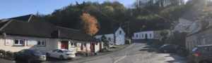
Glenmore: Between Waterford and New Ross [Updated]

As touched upon in our previous post regarding the Glenmore Post Office, the main Waterford to New Ross road has always passed through the parish of Glenmore. Today, before the Rose Fitzgerald Kennedy bridge opens crossing the River Barrow at the Pink Rock in Glenmore and bypasses the town of New Ross, the distance of the N25 between the Rice Bridge of Waterford and the O’Hanrahan Bridge of New Ross is 13.4 miles.

Danny Dowling has recorded the rich oral tradition of Glenmore and his notebooks contain information regarding ships, railway, roads, and lanes that linked Glenmore to both Waterford and New Ross. Today, on the verge of the opening of the New Ross by-pass Danny wanted to highlight the known changes through Glenmore of the main road from Waterford to New Ross.
Main Road Between Waterford & New Ross
There are several old maps available on line primarily held by Trinity and UCD. Trinity has the Down Survey Maps of 1656-1658 available at http://downsurvey.tcd.ie/down-survey-maps.php. This survey was supervised by the Surgeon General of the British Army, Dr. William Petty. The purpose of the survey was to measure and record the lands owned by Catholic landholders that were forfeited. These forfeited lands were then to be distributed to English soldiers and other Cromwell supporters.
UCD has a collection of old maps available at https://digital.ucd.ie/view/ivrla:426. Maps in this collection include a 1711 map by Charles Price which is entitled “A Correct Map of Ireland, Divided into Provinces, Counties and Baronies and Showing Road…” and a 1762 map by John Rocque with a longer title, “A Map of the Kingdom of Ireland, Divided into Provinces, Counties & Baronies, Showing the Archbishop, Bishops, Cities, Burroughs, Market Towns, Villages, Barracks…Ferries, Passes: Also the Great, the Branch and the by Post Roads.”

From a Glenmore perspective the three maps above are important more from what they do not show than what they do show. Glenmore does not appear as either a market town or village. A ferry is depicted at Ferrybank and at Rosbercon. The road between Waterford and New Ross is depicted as almost a straight line from Ferrybank to Rosbercon, with little detail provided along the length of the depicted road in these eighteenth century maps.
Prior to the old mail coach road local tradition indicates that the path of the oldest known road between Waterford and New Ross commenced in Ferrybank. This road then went to Mile Post into Slieverue Village and onto what is now Glenmore Village via the High Road down through the Churns across the village stream out through Cappagh and onto Ballygurrim to Butterbridge, and onto the ferry at Rosbercon. It is believed that the “main road” made use of existing lanes that linked villages and hamlets. The road that locally became known as “the churns” derived its name from two markers shaped like churns near its intersection with the High Road.

The mail coach road shortened the journey because it was more direct. This is believed to be the road depicted in the 18th century maps. From Ferrybank the mail coach road went to Mile Post, through Slieverue Village and onto Glenmore parish. The road turned at Donovan’s Mill and followed the “High Road” across the townlands of Scartnamore, Rathinure, onto the Halfwayhouse in Aylwardstown, where the horses would be changed. Instead of turning left at the Churns to go down into the Village of Glenmore, the old mail coach road went past Forristal’s Mill in Graiguenakill, onto Forristalstown, Shambough past the old Shambough school, to Butterbridge, to Rosbercon and onto New Ross.
Travel Between Waterford & New Ross in 1829
Update: 16 June 2023–thanks to Andrew Doherty of Waterford Tides and Tales who shared the following 1829 article that describes the road between Waterford and New Ross.
“COMMUNICATION BETWEEN WATERFORD AND ROSS. —That beautiful little steamer the Eclipse arrived the quay at ten o’clock morning from Ross with between twenty and thirty passengers, performing the voyage which is eighteen miles, in two hours. This vessel is quite new and has been brought over from Bristol to see if she can made to answer on our river. We think there is little doubt of the fact. As a mode of conveyance between this and Ross, it will have many advantages.
The present road is quite abominable —rough, and all up and down hill, so much so that the nominal riders per car are very frequently in the predicament of our countryman in the bottomless sedan-chair, who said, if it war’n’t for the honour of the thing, he’d as live walk.’ In fact our travellers on this primitive road, who by the national vehicle, commonly half the way on foot, through sheer necessity; and this pleasant journey of ten miles usually occupies three good hours!” (Waterford Mail – Sat. 16 May 1829, p. 4)
This road was in use as the main road until 1836. Just three years earlier in 1833 the road became notorious when a landlord was attacked and stoned to death in Shanbough “at the Glenmore hill” as he travelled in his gig from Waterford to New Ross. For further details on this murder click here.

The New Line
In 1836 the “New Line” was built through Glenmore parish and shortened the journey between New Ross and Waterford. Instead of turning at Donovan’s Mill and following the High Road the New Line was built to run from Carriganurra to Gaulestown. A Halfwayhouse was built at Ballinaraha, Glenmore and marked the halfway point between Waterford and New Ross. The New Line continued along the top of the Village of Glenmore and at this point it ran parallel to the old mail coach road and intersected the Churns. Thereafter it went toward the river via the Pink Rock went on through Shanbough to Raheen and to the New Ross Bridge. It is believed that after the 1798 Rebellion the military acknowledged the need for a better road system to move troops. Many of the roads improved in the early part of the 19th century were designed by the military. One of the more interesting details concerning the building of the New Line through Glenmore is the fact that several local women and girls worked on its construction.
Update of 4 June 2021–the following was found regarding the building of the new line along the Barrow (Waterford Chronicle Sat. 5 March 1836, p. 7_–Letter to the Editor of the Waterford Chonicle, Ross, February 23d, 1836
“Sir—Permit me through the columns of your independent paper to draw the attention of those persons concerned in the navigation of the river between Cheek Point and New Ross, to what, if permitted to be carried on much longer, will render the navigation of vessels of a large class to the town wholly impeded, and I trust if this letter meet the eye of the contractor of the new line of road to Waterford, via Lucy Rock, he will see the necessity of discontinuing a practice which would eventually be incalculable injury to the trade of Ross.
Whether by order of such contractor, immense quantities of stone rubbish and stuff, dug in making the new road above mention, are thrown over the rock into that part of the river called the West Channel, and at the very narrowest part too, not being more than 45 or 50 feet wide at his point; ‘tis most unwarrantable, this being heretofore the safest and deepest part for vessels of a large draft of water, flowing eight fathoms and a half at low water. But if the practice I have allude to is continued, the flow being so narrow at this point, it would eventually become as shallow as other parts of the river. If such conduct on the part of those road makers be not immediately discontinued, I call on the merchants and shipowners of Ross, in defence of their trade and the navigation of the river, to take immediate steps for its prevention. Your obedient servant, Michael Dunn, pilot”
N25
Today, the N25 through the parish of Glenmore generally follows the New Line except when it was completed in about 1991 the new road bypassed going along the river at the Pink Rock. Also, the portion of the Churns from the High Road crossing the New Line was closed. Today, a large roundabout now sits near the site of Forristal’s Mill in Graiguenakill and the Glenmore Roundabout will allow motorists to bypass New Ross.
The Old Bridges at Waterford & New Ross
The two bridges that connected Glenmore to Waterford and New Ross were very important to our ancestors. A timber bridge has spanned the River Suir at Waterford from 1794 and survived until 1910. The old timber bridge was referred to as “Timbertoes,” and was built by Lemuel Cox of Massachusetts. It remained a toll bridge for a century.
[Update 14 Aug. 2022–The New Ross Standard published on 4 Oct. 1907 (p. 6) that “At midnight on the 31st Dec. next the Toll Bridge at Waterford will be, henceforward thrown open free to the public.”]
The first bridge at New Ross was built in 1779, and it survived until January 1867 when it was destroyed by an ice flow. On 8 December 2019 Danny related that locals often reported that old Jim Culleton (1867-1962) of Kilbride, Glenmore was born the night the New Ross Bridge fell. The mid-wife from Ross was not able to attend his birth because the bridge at New Ross collapsed. A quick check of the parish records revealed that James Colleton (sic) the son of John Colleton (sic) and Brigid Walsh was born at Kilbride on the 22nd of January 1867 and baptized on the 24th. A newspaper article that appeared in the Waterford News reported on Friday the 25th of January 1867 that the bridge at New Ross collapsed the previous Saturday i.e. the 19th of January. This article contains some interesting information concerning the bridge and because it was privately owned it too appears to have been a toll bridge.

Special thanks to Louise Walsh for the photos and Peter Walsh for the representational drawing of the New Line and Old Mail Road.
Dr. Kathleen Moore Walsh
Kathy,
Is the murder you mentioned the murder of the landlord involving our Kennedy ancestor whose house they had the planning meeting at? Will there be information about his time in goal?
Hi Anne, The murder victim was Mr. Leonard and the two men who were convicted and hanged at the site of the murder were Meany and Malone. I’ll check with Danny to see what he has regarding their treatment while awaiting trial in Kilkenny. Please tell your Mom, Merry Christmas! Kathy
Oh right Meany not Kennedy. Yes I would like to have as much info as possible on that story. Merry Christmas to you as well!